
Free Download “5 Things You Must Know Before Traveling to Xinjiang”!
Get Free Instant Access to this useful resource by entering your name and email below. You’ll also receive monthly travel updates, exclusive offers and travel tips.
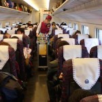
In December of 2014, Xinjiang’s first high speed train was opened to the public. At the time, it only reached as far as Hami, but in 2015 it connected the Xinjiang capital of Urumqi with the Gansu capital of Lanzhou. Here’s the story of this high speed train and my experience taking it. Sitting here […]
Read More ▸
A short distance south of Xinjiang’s capital of Urumqi there is a portion of beautiful land known as Nanshan, or “South Mountains”. For years tourist and locals have traveled away from the noisy, polluted city life seeking the peaceful scenery that Nanshan provides, but soon they will have an entirely different reason to visit: a new luxury golf course.
Read More ▸
Most foreigners these days are welcomed to Xinjiang with open arms. There is, however, a list of foreigners – both past and present – who will forever be scorned in the Xinjiang history books. This is the Xinjiang Most-Wanted Foreigners List.
Read More ▸
No tourist buses. No blazing hot sun beating down on me. No need to pay an entrance fee.
Just the pure joy of independent travel in my favorite province in China.
Read More ▸
It’s been 6 months already but a lot has happened. I believe these 15 pictures tell the story of this last half year well.
Read More ▸
What does it take to self-publish a travel guide? I take a look back at my publishing experience to review what it cost me and how successful the book has been so far.
Read More ▸
My Dearest Xinhua,I want to write a personal thank-you for your recent article about the year-long internet blackout here in Xinjiang. I can’t believe it’s been 10 years since the tragic Urumqi riots in July 2009 that resulted in a cut of all internet access, text messaging and international phone calls for 10 straight months. If […]
Read More ▸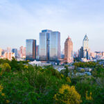
Urumqi, the capital of China’s western region of Xinjiang, is not as bad as everybody says it is. At least I don’t think so and I hope to prove that to you with these recent photos I’ve taken. Travel guides generally steer you away from Urumqi in favor of other Silk Road outposts and unfortunately […]
Read More ▸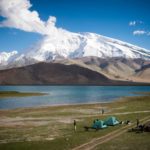
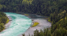
There is no doubt in mind that Xinjiang offers not only the most beautiful scenery in all of China, but also the most diverse. Considering that Xinjiang is the largest region in China, the ecological diversity should really come as no surprise. Indeed, as these 25 gorgeous Xinjiang photos prove, this place is unbelievable. Most […]
Read More ▸Kangjiashimenzi (康家石门子) is a collection of ancient petroglyphs that were carved into the side of a massive red-basalt rock in China’s remote region of Xinjiang. These carvings have been dated to about 2000 B.C. and they are believed to be the world’s earliest recordings of an ancient fertility ritual. Some call it an archeological wonder. […]
Read More ▸

From city guides to souvenir guides. From maps to hotel recommendations. Everything you need to plan your Xinjiang travel is here.
See More Resources ▸